Raster data is becoming more readily available for the United States. The LANDFIRE project has 30 m resolution fuels, topographic and vegetation data for the entire country. Lemma has created gradient nearest neighbor (GNN) data for the Pacific Northwest. The Wildland Fire Decision Support System (WFDSS) has raster data for land administered by the Forest Service. In addition, many forests derive raster data through cross-walking vegetation to fuels using field inventory data and remotely sensed data (such as LiDAR imagery and aerial photographs).
Regardless of the source of data used, a thorough critique is necessary, especially if the data will be used at the project-level. It is most likely that the data you use will, at minimum, need to be updated for recent management activities and/or recent wildfires. Establishing when and how your data were created, what sources of data were used to create the data (i.e., year of satellite imagery, vegetation layers, etc.), whether or not it has been reviewed by managers, etc. will help you determine what level of critique and update is necessary. For example, your data could have been created in 2006, but based on 2004 satellite imagery. Spending time researching these details will save you time in the long run. Stratton (2009) has written a GTR that provides a comprehensive approach for critiquing data as well as several suggestions on how to make modest and more complex changes to LCP files or the individual raster components using various applications. The Modify Raster Values tool within ArcFuels can be used to makecomplex modifications to a single raster and the Apply Treatment Adjustments options in the Build LCP Using Raster Data form can be used to modify multiple rasters at once which are not discussed in Stratton (2009).
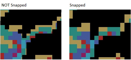
All raster data must have the same spatial reference (i.e., projection), resolution (cell size), and be snapped together (cells lined up). This is very important, if any of the data is projected differently or is lacking spatial reference ArcFuels10 will not work. In addition, if data is not snapped together ArcFuels10 will not work properly. Unlike other systems, the data does not all need to be the same spatial extent.
Seamless raster data and landscape files with coverage throughout the United States (including Hawaii and Alaska) are available through the LANDFIRE project. There are many versions of the data which are outlined below. Understand the differences and download the most appropriate data for your needs.
LANDFIRE version comparisons - for full details visit the Web page.
| Product | Imagery years | Disturbance image updates | Description |
|---|---|---|---|
|
National (LF_1.0.0) |
1999-2001 |
n/a |
Original LANDFIRE data products, used circa 2001 LANDSAT imagery |
|
Refresh 2001 (LF_1.0.5) |
1999-2001 |
n/a |
Enhanced LF_1.0.0 layers to allow comparison between the circa 2001 LANDSAT based image data products and LF_1.1.0 |
|
Refresh 2008 (LF_1.1.0) |
1999-2001 |
1999-2008 |
Updated LF_1.0.5 products to reflect vegetation changes and disturbances 1999 - 2008. |
| LF 2010 (LF 1.2.0) | 1999-2001 | 1999-2010 | Will reflect vegetation change and disturbance 1999 - 2010. |
| LF 2012 (LF 1.3.0) | 1999-2001 | 1999-2012 | Will reflect vegetation change and disturbance 1999 - 2012. |
| LF 2014 (LF 1.4.0) | 1999-2001 | 1999-2014 | Will reflect vegetation change and disturbance 1999 - 2014. |
| LF2015 | 2015 | n/a | Complete new re-map of all data - not yet started |
The easiest way to download LANDFIRE data is to use the LANDFIRE Data Access Tool (LFDAT) which is an ArcMap extension. With this tool it is easy to download the correct extent for your analysis area and the extent used can be saved for future data retrieval.
At a minimum data is required to characterize the fire landscape (items 1 to 8 in the list); however, additional data is needed for updating, creating fuel treatments, etc. The list below is not all inclusive but should serve as a good guide for obtaining data.
When obtaining raster data, be sure the resolution and projection is the same for all data. Also make sure the data is snapped (lined up at all the edges).

To continue to the next section go to Inventory data for FVS. If you do not have FVS data go to Setting up ArcFuels with Your Data.