In addition to or in place of raster data ArcFuels can be run using forest inventory data in a FVS ready database format. ArcFuels can be used to run FVS in a non-spatial context; however, it is most often used in conjunction with spatial data. If you would like to use inventory data spatially, in addition to the FVS ready database (which is described below), elevation, slope and aspect rasters are required plus a shapefile and stand raster that are linked to the FVS data.
| Required Data | Optional Data |
|---|---|
| Slope raster | Project boundary polygon/raster |
| Aspect raster | Past disturbance polygon/raster |
| Elevation raster | Highly valued resources polygon/raster |
| Stand polygon/raster | Treatment locations/types polygon/raster |
| FVS-ready database |
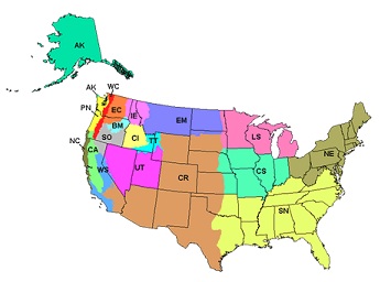
One important note is you must download the proper FVS variant file when using the FVS functionality in ArcFuels.

FVS variant map
FVS-ready data can be obtained from FSVeg or from FSVeg Spatial Data Analyzer (internal Forest Service web site). It is also possible to output and FVS-ready database from FFI (FIREMON/FEAT Integrated, Lutes 2009).
FSVeg is a Forest Service maintained data storage site containing inventory data about trees, fuels, and understory vegetation. Data collected during common stand exams, fuels specific data collection, permanent raster inventories (such as Forest Inventory Analysis (FIA) program) and other vegetation inventory are included. FSVeg is a resource for obtaining FVS ready databases.
Not all inventory data is in FSVeg and the best data might be locally collected and maintained data. It is possible that the FVS data from your local unit is not in a database form but there are pre-processing tools available on the FVS Web site that are helpful in converting the text files used to run Suppose (the FVS GUI) into a database compatible with ArcFuels. Refer to the FVS database extension guide for more detailed information.
FSVeg Spatial Data Analyzer is designed to help FSVeg users to understand the data through use of the FVS growth simulator and landscape vegetation analysis. The tool can also be used to impute FSVeg data to other stands in a landscape using a most similar neighbor imputation. This is limited to Forest Service employees.
FFI is a plot-level monitoring software tool designed to assist managers with collection, storage and analysis of ecological information. One of the data format outputs from the tool is an FVS-ready database.
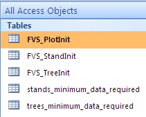
FVS-ready data can be created from common stand exams or monitoring data. An example database has been supplied with the demonstration data (Example_FVS_input_database.mdb) that includes both the complete FVS data tables and additional tables for the minimum data required . The FVS data field types are specific to the model needs if you are creating your own database start with the blank one supplied or from one created specifically for FVS using one of the database extensions or FSVeg. Blank FVS databases are also available on the FVS Web site.

Data tables in the example FVS database supplied with the Mt. Emily demonstration data. The database is named Example_FVS_input_database.mdb.
For a description of all the fields in each data table, use the design view in Access. This outlines what each field means and other important information such as units. Additional information can be found in the FVS documentation.

Design view of the FVS_TreeInit data table in the example FVS database. Not all fields are shown in the figure.
The stand, optional plot, and tree data tables are all linked through a unique stand identifier, STAND_ID. This linkage is necessary when building your own database. The table below is a simplistic view of this linkage.
Stand, plot and tree data table linkage example. All records in the stand, plot and tree tables must be linked by a unique identifier (STAND_ID) for each stand. There can be multiple plots per stand and multiple trees per plot as shown below. *The FVS_PlotInit data is only needed if you have more than one plot per stand.
| FVS_StandInit | FVS_PlotInit* | FVS_TreeInit | ||||
|---|---|---|---|---|---|---|
| STAND_ID | NUM_PLOTS | STAND_ID | PLOT_ID | STAND_ID | PLOT_ID | TREE_ID |
|
FVS_StandInit |
FVS_PlotInit |
FVS_TreeInit |
||||
|
STAND_ID |
NUM_PLOTS |
STAND_ID |
PLOT_ID |
STAND_ID |
PLOT_ID |
TREE_ID |
|
1 |
3 |
1 |
1 |
1 |
1 |
100 |
|
|
|
1 |
2 |
1 |
1 |
101 |
|
|
|
1 |
3 |
1 |
2 |
200 |
|
|
|
|
|
1 |
2 |
201 |
|
|
|
|
|
1 |
2 |
202 |
|
|
|
|
|
1 |
3 |
301 |
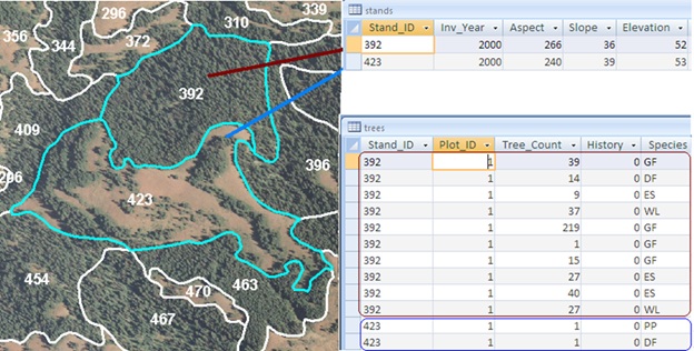
This is often the hardest part for getting your data to work in ArcFuels10. Regardless of the source of the FVS database obtained, properly linking the database to the stand polygon layer (and stand raster) is critical. There must be a relationship between the polygon identifier and the FVS stand table variable (STAND_ID). If data exist for every polygon there will be a unique stand and tree list for every stand within the polygon (a one-to-one relationship). This is the case with the demonstration data. If imputation (i.e,. Most Similar Neighbor (MSN) or Gradient Nearest Neighbor (GNN)) is used a single stand and associated tree list will be used for multiple polygons (one-to-many relationship).
No matter the relationship (one-to-one or one-to-many) there must be a field in the stand polygon that is identical to the FVS tables. It is highly recommended that this be the STAND_ID field.

Linkage between the GIS stand polygon layer and the FVS stand and tree data tables. All three are linked by a unique stand identification number. Having the imagery behind the stand polygon layer is a useful visual when looking at stand and tree data tables. In this example stand 392 is densely stocked as can be seen by the 10 tree list entries and 428 trees compared to stand 423 with two tree list entries and two trees.
For future sorting and joining it is recommended that a second stand identification field is added to the FVS data tables that is equal to the Stand_ID but is numeric. In the demonstration data (Mt_Emily_Database.mdb) this is the Stand_ID_NUM field.
To continue to the next section go to Setting up ArcFuels with Your Data.