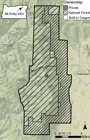

The supplied demonstration data are for the Mt. Emily wildland urban interface (WUI), located in northeastern Oregon. The Mt. Emily WUI is 40,385 ac (58% of which are federally managed lands) and is north of La Grande, OR.

About 30,300 ac of the area are forested, based on a 10% minimum canopy closure definition. The forest composition ranges from dry forests of ponderosa pine, to cold forests dominated by subalpine fir and Engelmann spruce, and a transition zone containing grand fir, Douglas-fir, and western larch (Ager et al. 2010).
The Mt. Emily study area is comprised of 1,081 stands (polygons).
A full set of demonstration data is available for completing the exercises within this tutorial. Data include:
Geospatial data included within the demonstration data folder. The “lf” data was downloaded from LANDFIRE (Refresh 2008, LF_1.1.0).
|
Data type |
Name |
Units |
Description |
|---|---|---|---|
|
polygon |
mt_emily_stands |
n/a |
Mt. Emily stands |
|
polygon |
mt_emily |
n/a |
Boundary of Mt. Emily project area |
|
raster |
stands |
n/a |
Raster version of Mt. Emily stands |
|
raster |
elevation |
m |
Elevation |
|
raster |
aspect |
azimuth |
Aspect |
|
raster |
slope |
degrees |
Slope |
|
raster |
lf_fbfm40 |
n/a |
Scott and Burgan (2005) fire behavior fuel model |
|
raster |
lf_cc |
% |
Canopy cover (a.k.a. canopy closure) |
|
raster |
lf_ch |
m*10 |
Canopy height (a.k.a. stand height) |
|
raster |
lf_cbh |
m*10 |
Canopy base height (a.k.a. height to live crown) |
|
raster |
lf_cbd |
kg/m3*10 |
Canopy bulk density |
|
raster |
subarea |
n/a |
Smaller sub-area within the study area |
|
raster |
fire |
n/a |
Hypothetical past fire |
|
polygon |
fire2009 |
n/a |
Hypothetical past fire |
|
polygon |
preplanned_treatment |
n/a |
Hypothetical fuel treatment plan |
|
raster |
ideal_trt |
n/a |
Hypothetical ideal treatment locations |
|
raster |
trt_location |
n/a |
Hypothetical fuel treatment alternative location |
|
raster |
trt_type |
n/a |
Hypothetical fuel treatment alternative type |
|
polygon |
ownership |
n/a |
Ownership |
|
polygon |
management_allocation |
n/a |
Resource and land management plan allocations |
|
point |
structures |
n/a |
Individual structures within the study area |
|
line |
roads |
n/a |
Road network within the study area |
|
raster |
hvra_xxx |
n/a |
0/1 rasters of various HVRA data |
|
SID |
mt_em.sid |
n/a |
NAIP imagery of the study area |
To learn how to set up the demonstration data go to: Setting up ArcFuels10 with the Mt. Emily Demonstration Data.