The communities of Island Park, ID, and West Yellowstone, MT, are situated just outside the western entrance to Yellowstone National Park amid grasslands, sagebrush, and aspen and conifer forests. As part of the broader interagency Cohesive Wildfire Management Strategy policy created in response to the FLAME Act of 2009, a collaborative group called the Island Park Sustainable Fire Community (IPSFC) formed to develop a dynamic long-term strategy for a 314,000-ha (750,000-acre) area encompassing the two communities. The IPSFC recognized the need to evaluate the existing wildfire risk in the area to facilitate prioritization efforts for future fuels treatment projects designed to modify fire behavior.
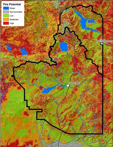
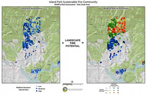
FMI Fire Behavior Specialist LaWen Hollingsworth and RMRS Fire, Fuel, and Smoke Science Program (FFS) Research Ecologist Russ Parsons, in collaboration with U.S. Forest Service Region 1/Region 4 and Caribou-Targhee National Forest, assisted the IPSFC in developing a risk assessment. Risk of wildfire was evaluated and classified based on three components: likelihood, intensity, and effects. Likelihood of wildfire was classified using burn probabilities from the Large Fire Simulator (FSim), a system used to estimate burn probability and variability in fire behavior across large landscapes. Fire intensity is summarized using flame lengths from the geospatial fire behavior system, FlamMap. Burn probabilities and flame length data were combined to produce a map of wildfire potential across the landscape. The effect, or value, is supplied by structure hazard assessments within the project area conducted in the Island Park and West Yellowstone communities. These data detailed ingress, egress, building materials, and hazards adjacent to structures such as overhanging vegetation or propane tanks. The structure assessment data were classified into low, moderate, or high structure hazard classes, which were then combined with the landscape wildfire potential data to create a matrix displaying the wildfire risk to structures. The risk assessment data will be used by IPSFC to evaluate and prioritize fuels projects and inform homeowners of potential risks from wildfires and their responsibilities to mitigate those risks. Top image: Landscape fire potential for the Island Park Sustainable Fire Community (IPSFC) project area. Bottom image: The wildfire risk assessment map for the Yale Creek area, part of the IPSFC project area located directly north of Island Park Reservoir.