Evaluating the ecological benefits of wildfire by integrating fire and ecosystem simulation models
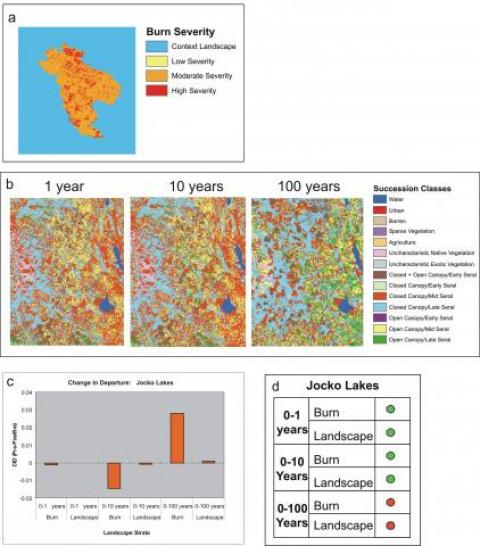
The accumulation of canopy and surface fuels, coupled with a general warming of the climate, have contributed to an increase in the frequency, severity, and size of wildfires in the western United States. Contemporary wildfires and their control have become a contentious issue in the US because they pose a threat to human life and property, they are costly to suppress, and they can cause ecological harm. On the other hand, these same wildfires can also reduce fuels, restore fire to fire-adapted ecosystems, and increase ecosystem health. Fire managers are now realizing that wildfires can be beneficial because they can reduce hazardous fuels and restore fire-dominated ecosystems. A software tool that assesses potential beneficial and detrimental ecological effects from wildfire would be helpful to fire management. This paper presented a simulation platform called FLEAT (Fire and Landscape Ecology Assessment Tool) that integrates several existing landscape- and stand-level simulation models to compute an ecologically based measure that describes if a wildfire is moving the burning landscape towards or away from the historical range and variation of vegetation composition. FLEAT uses a fire effects model to simulate fire severity, which is then used to predict vegetation development for 1, 10, and 100 years into the future using a landscape simulation model. The landscape is then simulated for 5,000 years using parameters derived from historical data to create an historical time series that is compared to the predicted landscape composition at year 1, 10, and 100 to compute a metric that describes their similarity to the simulated historical conditions. This tool was designed to be used in operational wildfire management using the LANDFIRE spatial database so that fire managers can decide how aggressively to suppress wildfires. Validation of fire severity predictions using field data from six wildfires revealed that while accuracy is moderate (30-60%), it is mostly dictated by the quality of GIS layers input to FLEAT. Predicted 1-year landscape compositions were only 8% accurate but this was because the LANDFIRE mapped pre-fire composition accuracy was low (21%). This platform can be integrated into current readily available software products to produce an operational tool for balancing benefits of wildfire with potential dangers.

