The first comprehensive assessment of where public wildlands in the Western US potentially contribute wildfire exposure to communities.
Predicting wildfire disasters presents a major challenge to the field of risk science, especially when fires are propagated over long distances through diverse fuel types and complex terrain. A good example is in the western US were large tracts of public lands routinely experience large fires that spread from remote wildlands into developed areas and cause substantial structure loss and frequently fatalities as well. In this project we provide the first comprehensive assessment of where public wildlands in the western US potentially contribute wildfire exposure to communities in the 11 western US states and provide a framework for assessing cross-boundary wildfire exposure and a case study application in the western US. The case study provides detailed mapping and tabular decision support in web portals for prioritizing fuel management investments aimed at reducing wildfire exposure to communities located proximal to national forests. The methods from this research are also being used to respond to EO 13855: (i) Identify DOI- and USDA FS-administered lands ………where there is a high probability that wildfires would threaten people, structures, or other high-value assets, in order to direct and prioritize actions to meet land management goals and to protect communities.
Existing risk assessment technologies and frameworks measure in-situ risk and do not identify how risk is linked to the source in terms of the ignition location or spread through landscape fragmented by fuels, ownership, and other factors that can affect fire spread. In this project we use newer assessment methods developed by Forest Service researchers to explicitly measure and map wildland-community wildfire transmission and assess current exposure to communities in the western US. Using these methods, areas that propagate wildfires into communities can be identified and prioritized for fuel management.
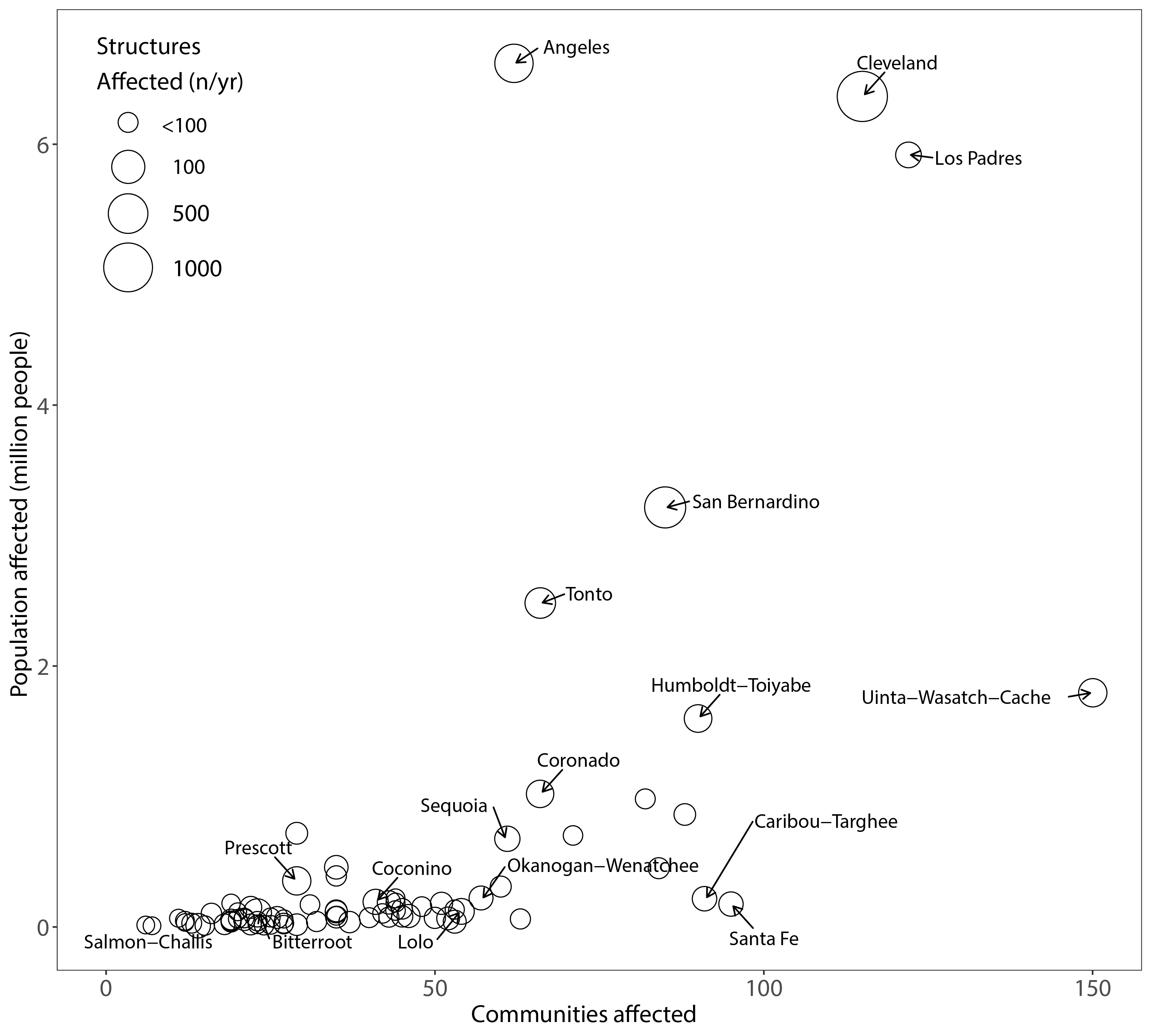
How many communities potentially affected by future wildfires?
- We estimate a total of 1,812 communities in the western US could be significantly impacted by future wildfires (“significant” is defined as > 1 structure per year on average).
- Ignitions on national forest lands will likely affect 516 of these 1,812 communities (> 1 structure per year on average).
- For comparison, Paradise CA ranked 189th out of the 1,812 communities exposed to all fires in the western US.
How many structures in these communities are exposed by wildfires?
- We estimate ignitions on all lands will expose 19,400 structures to wildfire per year on average. The modeling estimates structure exposure from wildland fires, not structure to structure fire within communities.
- Of the total exposure, ignitions on national forest lands will expose an estimated 4,000 structures (21% of total) in the western US per year on average.
- Due to administrative restrictions on national forest lands, only about half of this exposure (2,200 structures) originates on lands where mechanical treatments can be conducted.
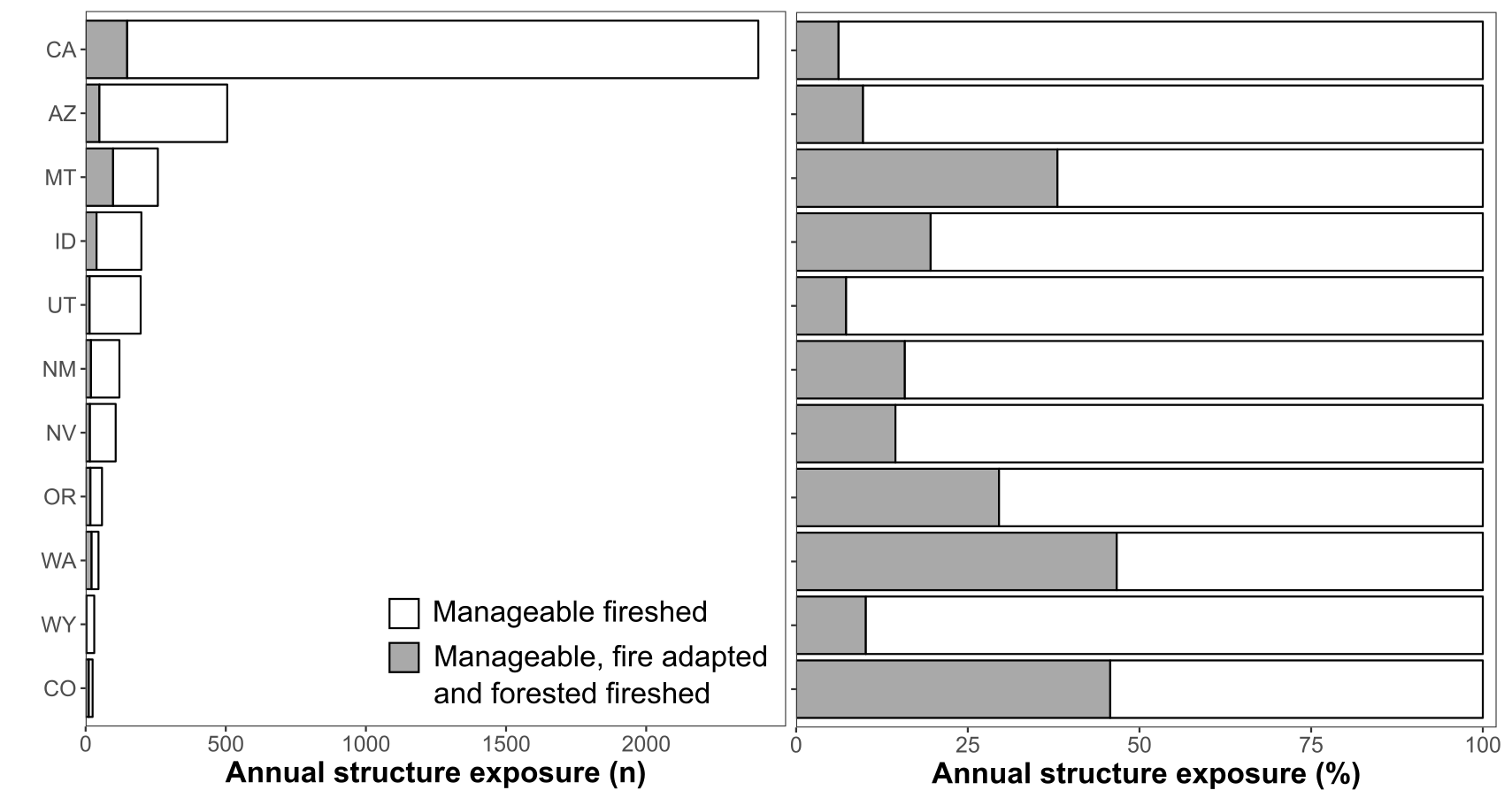
How large are the community firesheds, i.e. the source area for wildfires that expose communities?
- There are an estimated 240 million acres in the western US where fire ignitions are likely to expose communities to wildfire.
- There are an estimated 57 million acres on western national forests where fire ignitions are likely to expose communities. This amounts to 41% of the national forest land in the western US.
- Of the 57 million acres of national forest land where fire ignitions are likely to expose communities, due to administrative restrictions 34 million acres are available for mechanical treatment (60%).
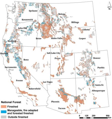
The products from this research are being used in the Scenario Investment Planning Platform to understand where fuel management can be leveraged to reduce cross boundary and community risk. The following graphics are Wildfire exposure to the wildland urban interface in the western US.